
Featured
More Freezing Rain, Ice Possible Tonight; Chance of Snow Friday Morning
By Alyssa Schnugg
News editor
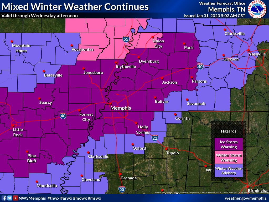
More freezing rain and ice are possible today through Wednesday, according to the National Weather Service.
Lafayette County is currently under a Winter Weather Advisory that remains in effect until noon on Wednesday. If ice accumulates, it could cause power outages and tree damage as well as hazardous traveling conditions.
Oxford and Lafayette County schools delayed opening today for two hours. No announcements about any changes to the school openings for Wednesday were made as of 10 a.m. Today.
There’s a slight chance of rain or freezing rain today before 1 p.m. until the high temperature hits about 37 degrees. Little or no ice accumulation is expected this morning.
Rain and freezing rain is expected to return this evening with rain expected before 7 p.m. and then becoming all freezing rain after 7 p.m. The low tonight will hit about 28 degrees. New ice accumulation of .1 to .3 of an inch is possible.
On Wednesday, more freezing rain before 10 a.m. followed by more rain showers. The high should reach 40 degrees.
More rain Wednesday night with a low of 34 degrees. No ice accumulation is expected for Wednesday night.
Thursday will continue to be cold and wet with a high of 41 degrees and rain expected most of the day.
There is a slight chance of rain and snow before noon on Friday, then the sun could return in the afternoon with a high of 45 degrees. The low Friday will dip to 26 degrees.
The weekend should be clear, with highs Saturday and Sunday around 50 to 55 degrees and lows around 35 degrees.
Hotty Toddy News will post updates about any closings and other weather-related information as it becomes available on its Facebook and Twitter pages.

| Mon, Nov 4 |  | vs Long Island University | W, 90-60 |
| Fri, Nov 8 |  | vs Grambling | W, 66-64 |
| Tue, Nov 12 |  | vs South Alabama | W, 64-54 |
| Sat, Nov 16 |  | vs Colorado State | W, 84-69 |
| Thu, Nov 21 |  | vs Oral Roberts | L, 100-68 |
| Thu, Nov 28 |  | vs BYU | W, 96-85 OT |
| Fri, Nov 29 |  | vs 13 Purdue | L, 80-78 |
| Tue, Dec 3 |  | @ Louisville | W, 86-63 |
| Sat, Dec 7 |  | vs Lindenwood | W, 86-53 |
| Sat, Dec 14 |  | vs Southern Miss | W, 77-46 |
| Tue, Dec 17 |  | vs Southern | W, 74-61 |
| Sat, Dec 21 |  | vs Queens University | W, 80-62 |
| Sat, Dec 28 |  | @ Memphis | L, 87-70 |
| Sat, Jan 4 |  | vs Georgia | W, 63-51 |
| Wed, Jan 8 |  | @ 23 Arkansas | W, 73-66 |
| Sat, Jan 11 |  | vs LSU | W, 77-65 |
| Tue, Jan 14 |  | @ 5 Alabama | W, 74-64 |
| Sat, Jan 18 |  | @ 17 Mississippi State | L, 81-84 |
| Wed, Jan 22 |  | vs 13 Texas A&M | L, 62-63 |
| Sat, Jan 25 |  | @ Missouri | 5:00 PM SECN |
| Wed, Jan 29 |  | vs Texas | 8:00 PM ESPN2 |
| Sat, Feb 1 |  | vs 2 Auburn | 3:00 PM TBA |
| Tue, Feb 4 |  | vs 10 Kentucky | 6:00 PM ESPN |
| Sat, Feb 8 | | @ LSU | 7:30 PM SECN |
| Wed, Feb 12 |  | @ South Carolina | 6:00 PM SECN |
| Sat, Feb 15 | | vs 17 Mississippi State | 5:00 PM TBA |
| Sat, Feb 22 |  | @ Vanderbilt | 2:30 PM SECN |
| Wed, Feb 26 | | @ 2 Auburn | 6:00 PM TBA |
| Sat, Mar 1 |  | vs 12 Oklahoma | 1:00 PM TBA |
| Wed, Mar 5 |  | vs 1 Tennessee | 8:00 PM TBA |
| Sat, Mar 8 |  | @ 6 Florida | 5:00 PM SECN |