
Featured
A Couple More Days of Extreme Heat, Then Relief Expected to Arrive

By Alyssa Schnugg
News editor
Cooler temperatures are just around the corner for the Mid-South. We just have to get through the weekend.

Today will likely hit 100 degrees this afternoon, with the heat index value reaching 110.
An Excessive Heat Warning remains in effect in Lafayette County through Saturday night.
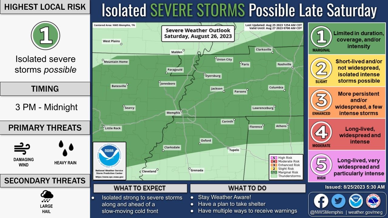
The high on Saturday is expected to be around 98 degrees. There is a 20 percent chance of showers and thunderstorms after 1 p.m.
The National Weather Service has Lafayette County as having a “Marginal” risk for severe weather Saturday from 3 p.m. to midnight. Heavy rain and gusty winds are possible.
The possible rain is due to an incoming cold front that will drop temperatures into the low to mid-80s.
There is a 40 percent chance of rain on Sunday after 10 a.m. The high is expected to reach 90 degrees, with a low around 71.
Monday’s high is expected to be near 86. There’s a 20% chance of a thunderstorm Monday afternoon. The highs are forecast to be around 83 degrees Tuesday through Thursday.
Read Hotty Toddy News Monday for a closer look at the weather expected next week.

| Mon, Nov 4 |  | vs Long Island University | W, 90-60 |
| Fri, Nov 8 |  | vs Grambling | W, 66-64 |
| Tue, Nov 12 |  | vs South Alabama | W, 64-54 |
| Sat, Nov 16 |  | vs Colorado State | W, 84-69 |
| Thu, Nov 21 |  | vs Oral Roberts | L, 100-68 |
| Thu, Nov 28 |  | vs BYU | W, 96-85 OT |
| Fri, Nov 29 |  | vs 13 Purdue | L, 80-78 |
| Tue, Dec 3 |  | @ Louisville | W, 86-63 |
| Sat, Dec 7 |  | vs Lindenwood | W, 86-53 |
| Sat, Dec 14 |  | vs Southern Miss | W, 77-46 |
| Tue, Dec 17 |  | vs Southern | W, 74-61 |
| Sat, Dec 21 |  | vs Queens University | W, 80-62 |
| Sat, Dec 28 |  | @ Memphis | L, 87-70 |
| Sat, Jan 4 |  | vs Georgia | W, 63-51 |
| Wed, Jan 8 |  | @ 23 Arkansas | W, 73-66 |
| Sat, Jan 11 |  | vs LSU | W, 77-65 |
| Tue, Jan 14 |  | @ 5 Alabama | W, 74-64 |
| Sat, Jan 18 |  | @ 17 Mississippi State | L, 81-84 |
| Wed, Jan 22 |  | vs 13 Texas A&M | L, 62-63 |
| Sat, Jan 25 |  | @ Missouri | L, 83-75 |
| Wed, Jan 29 |  | vs Texas | W, 72-69 |
| Sat, Feb 1 |  | vs 2 Auburn | L, 92-82 |
| Tue, Feb 4 |  | vs 10 Kentucky | W, 98-84 |
| Sat, Feb 8 | | @ LSU | 7:30 PM SECN |
| Wed, Feb 12 |  | @ South Carolina | 6:00 PM SECN |
| Sat, Feb 15 | | vs 17 Mississippi State | 5:00 PM TBA |
| Sat, Feb 22 |  | @ Vanderbilt | 2:30 PM SECN |
| Wed, Feb 26 | | @ 2 Auburn | 6:00 PM TBA |
| Sat, Mar 1 |  | vs 12 Oklahoma | 1:00 PM TBA |
| Wed, Mar 5 |  | vs 1 Tennessee | 8:00 PM TBA |
| Sat, Mar 8 |  | @ 6 Florida | 5:00 PM SECN |