News & Views
Tornado Spotted in Lafayette County; No Reports of Damage
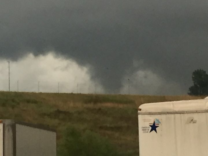
A photo of a tornado was captured early this morning by Oxford Emergency Management Coordinator Jimmy Allgood behind the Emergency Operations Center off McElroy Drive.

By Alyssa Schnugg
News editor
alyssa.schnugg@hottytoddy.com

Photo by Oxford Emergency Management via NWS Facebook
A photo of a tornado was captured early this morning by Oxford Emergency Management Coordinator Jimmy Allgood behind the Emergency Operations Center off McElroy Drive.
At about 6:30 this morning, tornado warnings were issued by the National Weather Service for Oxford and Lafayette County. The rotation spotted in the clouds moved north of the Oxford-University Airport along Molly Barr Road and up along Highway 7.
Lafayette County Emergency Management Director Steve Quarles said his office had not received any reports of damage as of 8 a.m.
Allgood confirmed.
“We’ve had no reports of damage, injury or power outages,” he said. “I don’t think it actually touched down.”
The early morning storms came from the outer bands of what was Hurricane Laura that hit the Lousiana/Texas coastline Wednesday night.
The tornado warning caused the Oxford School District to delay opening schools. Elementary students started school at 8 a.m. and secondary school students started at 9 a.m.
No major power outages were reported by the Oxford Utilities or North East Mississippi Electric Power Association.
More storms and windy conditions are expected to last throughout the day, with gusts up to 25 mph possible.
Allgood said “pop-up” tornadoes are still possible today as the bands continue to come through the state.
“Stay aware because there is the potential of these short-lived, pop-up tornadoes today,” he said.
Rain remains in the forecast for the next several days; however, winds should die down to 5 mph by Saturday, according to the National Weather Service.
This is a developing story. Check with Hottytoddy.com for updates.


