Oxford’s Emergency Management Director Jimmy Allgood released the following statement today at 11:06 a.m.
Event 1 – We will go under a winter weather watch beginning at 12:00 noon on Friday, and will end at 9:00 p.m on Friday.
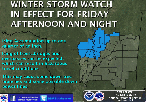
We can expect from 1/10 inch up to ¼ inch of freezing rain accumulations on elevated structures, power lines, and trees.
The NWS in Memphis and Jackson are stressing that an uncertainty remains regarding accumulation amounts, we may see more or less.
We can expect 15 to 25 mph winds, with some gusts as the front approaches up to 60 mph.
Wind chill temps will be in the teens.
We can expect the frozen precipitation to begin around mid-afternoon on Friday.
Event 2 – Saturday afternoon and Saturday evening
Additional accumulations of freezing rain is possible, with no amounts available at this time.
Travel to and From Jackson (Friday and Saturday)
Expect rain, light freezing rain, and high winds.
Light icing on elevated structures is possible which can cause travel hazards.
The next Teleconference with the NWS offices and State Emergency Management will be at 10 a.m. on Friday.
*************************************************************************************************
The Mississippi Business Journal released the following information on Dec. 5 regarding the same winter storm system.
Those dreaming of a white Christmas in Northwest Mississippi might get more than they hoped for later this week.
Emergency management officials are cautioning residents about the dangers associated with an approaching winter storm expected to bring ice, sleet and possibly snow to the mid-South region.
The National Weather Service says counties in eastern Arkansas, Northwest Mississippi and West Tennessee will be under winter storm watches and warnings Friday. Temperatures are expected to drop into the 30s.
Forecasters say travel will be hazardous and power outages are possible.
The weather service said yesterday that the area likely to be the most affected by ice is northeast Arkansas and northwest Tennessee.
Officials are monitoring road conditions. Motorists should check their cars’ tires, windshield wipers and antifreeze levels.
